*** START OF THE PROJECT GUTENBERG EBOOK 62156 ***
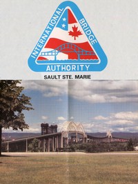
INTERNATIONAL BRIDGE AUTHORITY
SAULT STE. MARIE
The International Bridge Authority is a board composed of members from
the Province of Ontario and the State of Michigan. Its purpose is to
oversee management and operation of the International Bridge.
For information, write to:
P.O. Box 317
Sault Ste. Marie, MI 49783
[Illustration: Sault Ste. Marie Bridge]
BRIDGE FACTS
Name: The Sault Ste. Marie International Bridge
Length: Total maintenance length from American and Canadian
approaches—2.8 miles.
Cost: $20,000,000.
Designers: Steinman, Boynton, Gronquist & London, New York.
Construction: Started September 16, 1960. Opened to traffic October
31, 1962.
Width: 28 foot roadway between curbs, providing 14 foot
traffic lanes in each direction.
Tolls: $1.50 each way for passenger cars. No extra charge
for passengers. Canadian money accepted at par.
Height: Roadway is 145 feet above ground level at its highest
point.
Clearance: Bridge has 124 feet minimum vertical clearance above
low water in ship canals.
Weight: 125,000 tons of which 114,000 tons are concrete and
11,000 tons are structural steel.
Colors: Green and ivory.
Speeds: Maximum 30 miles per hour.
FROM DREAMS TO REALITY
The ease of traveling through the Locks or over the St. Mary’s Rapids is
now taken for granted but the dreams of building these structures began
over a hundred years ago, just after Michigan became a state in 1837.
[Illustration: Canoes crossing the river]
Traveling from one side of the river to the other first began in canoes.
Bands of Ojibwa Indians would camp and fish at the rapids they called
“Bawating”, meaning rushing water.
The rapids became a gathering point for as many as 50,000 Native
Americans each summer, for centuries.
In the 1600’s it became a settlement for French explorers and fur
traders.
Through wars control of the rapids went to the British in the mid 1700’s
and finally, a shared border with the United States in the 1800’s.
[Illustration: Building a lock]
As copper and iron ore were discovered in the western Upper Peninsula in
1830, ship traffic increased but had to be portaged over land at the
rapids. This difficult task eventually led to construction of the first
lock in 1855, and the second in 1871, a joint venture between the State
of Michigan and the U.S. Government.
In 1880, the first land transportation over the river between the U.S.
and Canada was established with a railroad bridge. In 1895, the Canadian
Lock was completed.
In 1943 and 1969 two other U.S. locks were built, one of which is
capable of carrying the 1000 ft. super freighters.
From the 1880’s til the 1960’s the only forms of transportation across
the St. Mary’s River, between the two Saults, were ferries and the
railroad bridge.
The inconvenience and delays of those days have been eliminated, thanks
to the International Bridge.
SAULT STE. MARIE
“Rapids Of Sainte Mary”
INTERNATIONAL BRIDGE
[Illustration: The bridge site]
Nearly a decade of engineering study, legislative action in Lansing,
Washington, Toronto, and Ottawa, and the sale of bonds to finance the
project preceded construction of the bridge. Michigan Governor G. Mennen
Williams and Ontario Treasurer James N. Allen were the main participants
in groundbreaking ceremonies for construction of the bridge on September
16, 1960.
[Illustration: Bridge piers under construction]
Dr. Carl Gronquist of the consulting engineering firm, Steinman,
Boynton, Gronquist and Birdsall, designed the two-mile long bridge
supported on 62 piers that would cost $20,000,000. The Michigan State
Highway Department agreed to construct the Michigan approach to the
bridge, a project costing very close to $4,000,000, which was tied into
the Interstate Freeway system and financed 90 percent by federal funds.
The International Bridge Authority then proposed a bond issue of
$16,250,000 to raise the remainder of the money.
The issue was divided into $8,400,000 in Series A bonds to be sold on
the New York market, and $7,850,000 in Series B bonds, all to be retired
within 40 years from bridge revenues. To facilitate financing, the
Province of Ontario bought the entire Series B bonds in one sale and
thus guaranteed a quick sale for the Series A bonds in the United States
bond market.
The International Bridge was opened to traffic on October 31, 1962.
[Illustration: Bridge span under construction]
Sault Ste. Marie, Michigan
Sault Ste. Marie, Ontario
[Illustration: The completed bridge]
THE BRIDGE VIEW
Located to the west of the locks and running parallel with the railroad
bridge, the International Bridge “takes off” from the U.S. side near the
campus of Lake Superior State University which overlooks the area from
the site of the former Fort Brady.
As you enter the first archway, the world famous Soo Locks are visible
below.
Further on, you’ll pass the International Boundary at the middle of the
Bridge. Off to the west you’ll see a series of 16 gates. These gates
control the water flow from Lake Superior down to the other connecting
Great Lakes. The management of this water flow is operated by the
International Joint Commission which makes determinations of gate
activity based on the various lake levels.
Within the rapids area, produced by the water rushing through the gates,
there is a concrete berm, or wall, stretching about one quarter of a
mile. The berm was constructed as a joint operation by the electric
utilities of the U.S. and Canada. Its objective is to keep an adequate
water flow around Whitefish Island, a natural spawning ground for
salmon.
[Illustration: The river below the bridge]
Just beyond Whitefish Island is the Canadian Lock and then the power
canal and the hydro-electric generating station of Great Lakes Power.
Approaching Sault, Ontario, there is an excellent view of the city’s
growing industrial complex with huge plants of the Algoma Steel
Corporation—one of Canada’s largest steel mills—to the west, and the St.
Marys Inc. paper plants to the east.
The volume of traffic between the two Saults has more than quadrupled in
the first twenty-five years of operation. Some 2,234,000 vehicles
crossed the bridge in 1987, as compared to 415,000 vehicles carried by
the ferries during their final full year of operation in 1961.
Published by Bill Davie, Trinity Productions.
[Illustration: THE ST. MARY’S INTERNATIONAL WATERWAY BETWEEN THE TWO
SAULT STE. MARIES
from Photograph taken 1978]
Transcriber’s Notes
—Silently corrected a few typos.
—Retained publication information from the printed edition: this eBook
is public-domain in the country of publication.
—In the text versions only, text in italics is delimited by
_underscores_.
End of the Project Gutenberg EBook of International Bridge Authority, Sault
Ste. Marie, by Anonymous
*** END OF THE PROJECT GUTENBERG EBOOK 62156 ***
Excerpt
INTERNATIONAL BRIDGE AUTHORITY
SAULT STE. MARIE
The International Bridge Authority is a board composed of members from
the Province of Ontario and the State of Michigan. Its purpose is to
oversee management and operation of the International Bridge.
For information, write to:
P.O. Box 317
Sault Ste. Marie, MI 49783
Name: The Sault Ste. Marie International Bridge
Length: Total maintenance length from American and Canadian...
Read the Full Text
— End of International Bridge Authority, Sault Ste. Marie —
Book Information
- Title
- International Bridge Authority, Sault Ste. Marie
- Author(s)
- Anonymous
- Language
- English
- Type
- Text
- Release Date
- May 17, 2020
- Word Count
- 1,064 words
- Library of Congress Classification
- HE
- Bookshelves
- Browsing: Culture/Civilization/Society, Browsing: History - American
- Rights
- Public domain in the USA.
Related Books

Wreck of the "London."
by Anonymous
English
479h 16m read

A day in Mary Carrow's school
by Anonymous
English
88h 8m read
La conqueste du chasteau d'amours conquestee par l'umilité du beau doulx
by Anonymous
French
126h 36m read

The war record of the Fifth Company, New England Regiment, Second Plattsburg Training Camp
by Anonymous
English
205h 3m read

Talon-Pojan Sää- eli Ilma-Kirja
by Anonymous
Finnish
39h 34m read
A brief history of the 3rd Battalion, 1st Punjab Regiment
by Anonymous
English
220h 40m read