*** START OF THE PROJECT GUTENBERG EBOOK 60989 ***
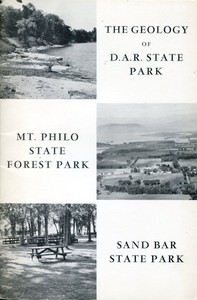
THE GEOLOGY OF
D.A.R. STATE PARK
[Illustration: Shoreline at D.A.R. State Park looking south.]
MT. PHILO STATE FOREST PARK
[Illustration: Panoramic view from west overlook on Mt. Philo.
Adirondack Mountains in background. Lake Champlain and Champlain
Lowlands in foreground.]
SAND BAR STATE PARK
[Illustration: Sand Bar State Park on flat surface of Lamoille River
delta. A part of extensive picnic area looking northwest.]
THE GEOLOGY OF
D.A.R. STATE PARK
MT. PHILO STATE FOREST PARK
SAND BAR STATE PARK
_By_
HARRY W. DODGE, JR.
VERMONT GEOLOGICAL SURVEY
CHARLES G. DOLL, _State Geologist_
DEPARTMENT OF FORESTS AND PARKS
ROBERT B. WILLIAMS, _Commissioner_
DEPARTMENT OF WATER RESOURCES
Montpelier, Vermont
1969
[Illustration: Fig. 1. Index Map.]
SANDBAR STATE PARK
MT. PHILO STATE PARK
BUTTON BAY STATE PARK
D.A.R. STATE PARK
LAKE CHAMPLAIN
Milton
Burlington
Shelburne Falls
Hinesburg
Vergennes
Bristol
Port Henry
Champlain Bridge
Middlebury
Crown Point
Shoreham
INDEX MAP
[Illustration: Fig. 1a. Surface of marine terrace at D.A.R. State
Park. Immediately to the left of shelter the land rises to a second
terrace.]
[Illustration: Fig. 2. View northwest along park beach. Illustrates
dip of rocks toward northwest; strike, northeast.]
THE GEOLOGY OF D.A.R. STATE PARK
INTRODUCTION
D.A.R. State Park is located in western Vermont on State Highway 17,
approximately 1 mile north of Lake Champlain (toll) Bridge (see map,
Fig. 1). The park, which fronts on Lake Champlain, contains undeveloped
acres on the east side of the Highway. Tenting, leanto camping,
picnicking and swimming are adequately provided for during the summer
months.
This park, more than most others, not only awakens the visitor’s
curiosity about the past history of the Earth, but satisfies it. The
story of an ancient sea and the life which existed in it can be read
from the rocks exposed in D.A.R. State Park. You can read this story for
yourselves. This Pamphlet is designed as an aid to a more complete
understanding of the observations which you make. “Reading the rock
record” is not difficult, but the geologist does have the advantage of
possessing a certain trained scientific approach to these problems. This
method of approach, the “tools of the trade,” will now be passed on to
you.
THE GEOLOGY OF THE PARK
The park beach is the ideal place to study the rocks of the park, for
here the rocks are best exposed and can be easily examined at close
range. The attitude of the rock layers can be seen on a walk down the
ramp. By attitude is meant their relationship to an imaginary horizontal
plane, which for our purposes is the level of the lake. Are the rock
layers parallel to the surface of Lake Champlain or do they slant or dip
into it? If the layers were parallel to the surface they would not
“dip.” The dip of the park strata (layers) is seen in Figure 2. Dip is
expressed in the number of degrees _down_ from the horizontal and here
the dip is toward the west and is measured to be between 8 and 11
degrees. The dip is always measured perpendicular to an imaginary
horizontal line on a rock layer called a “strike line.” The average
“strike,” or compass direction of the “strike line” is 22 degrees east
of _north_.[1]
_Sedimentary rocks_[2] crop out on the park beach. These were originally
lime mud resting on the sea bottom. Under continued pressure from the
overlying sediments resulting from continued deposition and burial, the
muds were slowly compacted and cemented into the hard limestones and
limy shales which we see today. The many layers of rock were then
tilted. Tilted layers tell the geologist of giant earth movements which
took place since their formation. The story of these movements will be
developed later in this pamphlet.
As you look at the tilted rock layers from the ramp, can you tell which
layers are the oldest, that is, those first deposited as lime muds on
the sea bottom? A basic geologic law, the Law of Superposition, states
that if a series of sedimentary layers have _not_ been overturned, the
oldest is on the bottom and the youngest on top. Assuming that the
layers which you are looking at have not been overturned, those on your
left (south) are the oldest and those on your right (north) the
youngest. Looking at Figure 2, taken from the ramp-bottom toward the
north, the layers in the foreground are older than those in the
distance. Let us take a close look at the individual layers of rock and
delve deeper into the story that they have to tell.
[Illustration: Fig. 3. Block diagram illustrating _dip_ and
_strike_.]
STRIKE DIRECTION
ROCK LAYER
SURFACE (PLANE) LAKE LEVEL
HORIZONTAL
DIP
ROCK LAYER
Search the top of a few layers and you will notice many shell and other
animal impressions. Do they represent animals which lived hundreds of
millions of years ago or were they washed onto these rocks from
present-day Lake Champlain? If you try to make a collection of the shell
impressions you will see that they are a part of the rock and therefore
must represent remains of animals that were buried in the ancient lime
muds. These preserved _remains_[3] are called fossils. The geologist who
specializes in the study of fossils is called a _paleontologist_. You
may ask, “What can fossils tell me about the past?” In the first place,
fossils tell us at what time in the past the sediments in which they are
found were deposited. In this way, the _relative age_[4] of the rock
layers found in the Park can be learned. Secondly, the environment or
surroundings in which these ancient sediments were deposited can be
reconstructed from the types of fossils contained within them. Certain
animals living today are quite similar to those in the Park rocks and
their environment in today’s sea can be used to reconstruct the
environment of animals which lived in the past. The characteristics of
the rocks and their relation to adjacent rocks are considered in any
reconstruction of past environment. In the third place, the study of
fossils is a mainstay of the theory of evolution. That is to say,
changes in fossil forms collected from groups of successively younger
rock layers document the theory that life has evolved little by little
since its first appearance on Earth. Finally, it should be mentioned
that some animals found as fossils are not living today and have not
lived, to the best of our knowledge, for millions of years. Why did
these forms of life die out? What set of circumstances led to their
extinction? The answers to these questions are not easy to find and they
are highly speculative.
[Illustration: Fig. 4. Standard Geologic Time Scale.]
GEOLOGIC TIME
ERA YEARS AGO PERIODS EVENTS
CENOZOIC 70,000,000 CENOZOIC MAN (1½ MILLION)
MESOZOIC 125,000,000 CRETACEOUS END OF DINOSAURS
165,000,000 JURASSIC FIRST BIRD
200,000,000 TRIASSIC FIRST DINOSAUR
PALEOZOIC 230,000,000 PERMIAN END OF TRILOBITES
260,000,000 PENNSYLVANIAN
290,000,000 MISSISSIPPIAN
330,000,000 DEVONIAN
360,000,000 SILURIAN
420,000,000 ORDOVICIAN ROCKS OF D.A.R. STATE
PARK
500,000,000 CAMBRIAN
BEGINNING OF FOSSIL RECORD
1 BILLION
2 BILLION
3 BILLION
4 BILLION
PRECAMBRIAN
THE FOSSILS
Many groups of invertebrates are represented in the fossils of D.A.R.
State Park. Plate 1 will help you to identify these fossils. The name,
phylum (major group) and age of each fossil are provided in the
explanation of the plate. The following paragraphs describe each phylum
represented in the Park rocks.
[Illustration: Plate 1. Typical fossils found in the Glens Falls
Limestone.]
_Arthropods._ D.A.R. State Park rocks contain trilobites with the
following imposing names: _Cryptolithus tesselatus_ (crip-toe-LITH-us
tessell-AH-tus[5]), _Isotelus gigas_ (ice-so-TELL-us GIG-us) and
_Flexicalymene senaria_ (flex-eye-cal-ah-Mean-ee sen-AREA). These
fossils are figured on Plate 1, 1-A, B, C, D; 2; 3. Within the Park
_Cryptolithus tesselatus_ is very common wherever fossils occur.
Generally only the cephalon or head portion of this trilobite is
preserved. The cephalon is easily recognized by three concentric rows of
pits arranged around the brim. _Cryptolithus_ is an excellent _index
fossil_[6] for the Park rocks. The arthropod phylum is characterized by
animals with jointed legs, segmented bodies and a jointed outer armour
of _chitin_.[7] For examples, the crabs, lobsters, spiders, scorpions
and insects are arthropods. Trilobites appear early in the fossil record
but they did not survive beyond the Paleozoic Era.
_Explanation for Plate 1_
(_all drawings are X1 unless otherwise indicated_)
1-A. _Cryptolithus tesselatus_, Arthropod (Trilobite), Middle Ordovician
(Trenton Stage). Front view of the Cephalon or head. (X2)
1-B. _Cryptolithus tesselatus_, Arthropod (Trilobite), Middle Ordovician
(Trenton Stage). Oblique front-lateral view of the Cephalon. (X2)
1-C. _Cryptolithus tesselatus_, Arthropod (Trilobite), Middle Ordovician
(Trenton Stage). Top view of the Cephalon. (X2)
1-D. _Cryptolithus tesselatus_, Arthropod (Trilobite), Middle Ordovician
(Trenton Stage). Side view of the Cephalon. (X2)
2. _Isotelus gigas_, Arthropod (Trilobite), Middle Ordovician. Top view
of specimen.
3. _Flexicalymene_, Arthropod (Trilobite), Ordovician to Silurian. Top
view of an enrolled specimen.
4-A. _Dinorthis pectinella_, Brachiopod, Middle Ordovician (Trenton
Stage). Exterior view of the brachial valve.
4-B. _Dinorthis pectinella_, Brachiopod, Middle Ordovician (Trenton
Stage). Exterior view of the pedicle valve.
5. _Reuschella edsoni_, Brachiopod, Middle Ordovician. Exterior view of
the pedicle valve.
6. _Lingula_, Brachiopod, Ordovician to Recent.
7-A. _Prasopora_, Bryozoan, Ordovician. Top view. (X0.5)
7-B. _Prasopora_, Bryozoan, Ordovician. Side view. (X0.5)
7-C. _Prasopora_, Bryozoan, Ordovician. Vertical thin section showing
the nature and growth of part of a bryozoan colony. (X18)
8. Bryozoan, “twig-like” type, Ordovician to Devonian.
9. _Sowerbyella_, Brachiopod, Middle and Upper Ordovician. Exterior view
of brachial valve. (X2)
10. _Rafinesquina_, Brachiopod, Middle and Upper Ordovician. Exterior
view of the pedicle valve.
11. _Platystrophia trentonensis_, Brachiopod, Middle Ordovician (Trenton
Stage). Anterior or front view.
12. _Hesperorthis tricenaria_, Brachiopod, Middle Ordovician (Black
River and Trenton Stage). Interior view of the pedicle valve.
[Illustration: Fig. 5. The surface of a layer or bed of Glens Falls
Limestone. Pen points to a colonial Bryozoan _Prasopora_ “head.”
These “heads” are very common just south or to your left if walking
down the ramp.]
_Brachiopods._ Brachiopods are abundant in the Park rocks (see Plate 1,
4A, B; 5; 6; 9; 10; 11; 12). These invertebrates are small marine
animals which generally live in waters no deeper than 600 feet. The two
valves of their shell are joined at the back (posterior) end of the body
along a hingeline of interlocking teeth and sockets. The shell of the
brachiopod is opened or shut by muscles attached to the inside of each
valve. Brachiopods are found in the oldest rocks containing definite and
abundant fossils. Brachiopods are still living today.
_Bryozoans._ Bryozoans or “moss animals” are very small marine animals
which live in colonies. The bryozoans construct their mutual home or
colony of lime which is commonly preserved for the fossil record. Large
colonies of the fossil Prasopora (prah-sop-OR-ah) are commonly seen on
the weathered surfaces of many of the rock layers in the Park (see Plate
1; 7A, B, C; 8 and Figure 5). Individuals of one genus common here, can
be recognized by their chocolate drop shapes. Bryozoans first appear in
lower Paleozoic rocks and are still living today in clear
well-circulated shallow to deep marine water. Considering all of the
fossils found in the Park rocks, the past environment is thought to have
been a relatively shallow and warm sea.
[Illustration: Fig. 6. This photograph shows the typical thickness
of the Glens Falls Limestone beds in the Park area. Note the massive
nature of the limestone bed. The 5-inch pen in the center of the
picture is for scale.]
[Illustration: Fig. 7. Sections illustrating the geologic history of
D.A.R. State Park.]
THE ROCKS AND THEIR HISTORY
Approximately 75 vertical feet of the Glens Falls Limestone occur along
the Park beach. The rocks are _black_[8] or blue-black on a fresh
surface, gray or grayish-white on a surface which has been exposed to
the weather. Most of the individual beds or layers are 5 to 7 inches
thick (see Fig. 6) with the thickest being just under 5 feet. The beds
are separated by thin “partings” of rock, many of which contain abundant
fossils. The beds consist of massive limestone, shaly limestone or limy
shale; the partings are generally limy shale or shaly limestone.
_Explanation for Figure 7_
1. Glens Falls and younger sediments were deposited on the Ordovician
sea floor.
2. Sediments hardened into Glens Falls Limestone and younger rocks.
3. Rocks were tilted during the late Ordovician Taconic Disturbance and
the younger rocks and part of the Glens Falls Limestone were removed by
erosion. Erosion continued for some 350 million years.
4. During the Pleistocene Epoch, which started some 1 million years ago,
glacial ice overrode the beveled layers of the Glens Falls Limestone.
Hard rocks frozen to the underside of the glacial ice produced scratches
or striations in the exposed layers of the Glens Falls Limestone.
5. Glacial lakes Vermont form as the glaciers retreat northward. In
between the glacial lakes Vermont and present Lake Champlain, marine
waters flooded the valley and formed an arm of the Atlantic Ocean. Clay,
silt, sand and gravel were deposited on glaciated Glens Falls Limestone
(Fig. 1a).
6. Present-day Lake Champlain formed when relatively greater uplift in
the north dammed the Champlain valley.
The rock types found in the Park lead to certain conclusions regarding
the environment which existed during their formation. Most of the rocks
are composed of lime (limestone) or a mixture of lime, fine sand and mud
(limy shale or shaly limestone). The mineral pyrite (FeS₂) is present in
many of the rocks. Most of the rocks contain abundant amounts of organic
matter. The sediments which make up these rocks were carried to the
Ordovician sea by streams flowing primarily from the east. As these
streams entered the quiet sea waters the larger followed by the smaller
particles began to settle to the bottom. Lime was slowly precipitated
from the warm sea water and pyrite formed under stagnant bottom
conditions. Organic material accumulated on the bottom and intermixed
with the sediments. The poor life-sustaining qualities of much of the
bottom waters prevented rapid or complete bacterial action on the
accumulated debris and the sediments remained “organic black” in color.
Slowly, as the weight of overlying sediments increased, the lower layers
were compacted and cemented into the hard limestone and shale which we
see today.
The tilt or dip of the Park rocks resulted from subsequent earth
movements. When were these rocks tilted? From the evidence presented in
the Park all that can be said is that they were tilted sometime after
hardening and before the Pleistocene glaciers overrode the region during
quite recent times (at least 10,000 years ago). Thus, there are some 350
million years of rock record missing in the Park. Can we tell what
happened during these “missing” years through a study of only the Park
rocks? The answer to this question is partially “yes,” but we must look
to the work done in adjacent areas for a more complete story.
The mere fact that there are no rocks representing these millions of
years tells us that the sea had withdrawn from the area and that the
previously deposited rocks were undergoing erosion during most or all of
the missing rock gap (the time not represented by rocks). Information
from adjacent areas, however, tells us that the Park rocks were tilted
during the Taconic Disturbance which occurred during the final stages of
the Ordovician Period. East of the Park, Taconic earth movements are
more dramatically exhibited. The rocks are tilted even more than in the
Park and are broken by faults or cracks in the earth’s crust. Some of
these faults, known as thrust faults, positioned giant slabs of rock far
from their original locations and placed older on top of younger rocks.
Following these earth movements there occurred a long period of erosion.
Many of the rock layers were stripped off and carried piece by piece by
rivers to other regions. Hundreds of millions of years passed and then,
less than one million years ago the great glacial ice sheets slowly
advanced southward over the Park area. Pieces of hard rock frozen to the
underside of the ice sheets scratched and scraped the rock surfaces
leaving these scratches or striations for us to see today (near the
northern end of the Park beach these striations are common on the
outcropping rock). The retreating glaciers created a series of lakes in
which clay, silt, sand and gravel were deposited. Today these sediments
are found resting on the beveled edges of the Park rocks.
Present-day Lake Champlain owes its existence to a general uplift of the
earth’s surface, greater in the north than in the south, perhaps due to
the removal of the heavy glacial ice sheet from the area. The greater
uplift in the north dammed the Champlain valley which slowly filled with
water. For a diagrammatic picture of the geologic history of D.A.R.
State Park, see Figure 7.
SUGGESTED READING
Beerbower, J. R., 1960, _Search for the Past_, Prentice-Hall, Englewood
Cliffs, N.J.
Collinson, C. C., 1959, _Guide for beginning fossil hunters_,
Educational Series 4, Illinois State Geological Survey, Urbana,
Ill.
Dunbar, C. O., 1959, _Historical geology_, John Wiley and Sons, New
York.
Fenton, C. L., 1937, _Life long ago_, The John Day Co., New York.
Goldring, Winifred, 1931, _Handbook of paleontology for beginners and
amateurs_, part 2, Handbook 9, New York State Museum, Albany, New
York.
—— ——, 1950, _Handbook of paleontology for beginners and amateurs_, part
1, Handbook 9, 2nd Edition, New York State Museum, Albany, New
York.
Moore, R. C., 1958, _Introduction to historical geology_, 2nd Edition,
McGraw-Hill Book Co., New York.
Shimer, H. W., 1933, _Introduction to study of fossils_, The Macmillan
Co., New York.
Simpson, G. G., 1953, _Life of the past_, Yale University Press, New
Haven, Conn.
Stokes, W. L., 1960, _Essentials of earth history_, Prentice-Hall, Inc.,
Englewood Cliffs, N.J.
Welby, C. W., 1961, _Bedrock geology of the Central Champlain Valley of
Vermont_, Vermont Geological Survey Bull. 14.
—— ——, 1962, _Paleontology of the Champlain Basin in Vermont_, Vermont
Geological Survey Special Publication 1.
[Illustration: Fig. 7a. View south from Mt. Philo Overlook.
Shellhouse and Buck mountains in the distance.]
[Illustration: Fig. 8. View looking north at western Overlook in the
summit area of Mt. Philo. Note Monkton Quartzite layers which are
dipping toward the northeast.]
THE GEOLOGY OF MT. PHILO STATE FOREST PARK
INTRODUCTION
Mt. Philo State Forest Park, consisting of some 160 acres, is located
about 15 miles south of Burlington and 1 mile east of U.S. Route 7 (see
map, Fig. 1). This park is noted for its scenic views, especially of the
broad Champlain Valley and the rugged Adirondack Mountains beyond (see
cover picture and Fig. 7a). From a 46-foot high observation tower a
panoramic view is easily gained. Picnic facilities, including stone
fireplaces, fuel wood, piped spring water and sanitary facilities are
available. A large rustic lodge with porch and portico provides
protection from sudden showers. Tenting on the top of Mt. Philo is not
allowed.
THE GEOLOGY OF THE PARK
_The Rocks_
The rocks of the Park which will probably first attract your attention
are those exposed at the main western Overlook which is located in the
summit area. This Overlook is found just northwest of the Park lodge
(see Fig. 8). These rocks are light to dark red or purplish in color,
are primarily _quartzite with minor dolostone_[9] dipping approximately
35 degrees to the northeast (for an explanation of dip, see Fig. 3 and
text of D.A.R. State Park, page 6) and striking toward the northwest
(for an explanation of strike, see immediately preceding reference).
A closer look at this Monkton Quartzite outcrop shows that it is made up
of several layers of rock (see Fig. 8). These layers, strata, or beds
are not all of the same thickness, but are generally from 1 inch to 1
foot thick. If an individual layer is traced over the extent of the
outcrop, it is found that its thickness remains about the same
throughout. It is therefore said to be regularly bedded. Thin
laminations of dark red shale are abundant and commonly define
individual layers. A magnified look at a specimen of this quartzite,
under a hand lens, shows that it is composed of fine to coarse fragments
of quartz. Some of these fragments have rounded edges, but others are
quite angular. The spaces between the fragments are filled with silica
(quartz). Therefore, the rock is said to possess a silica cement.
In many places where this Monkton Quartzite has been studied, features
attesting to a shallow water origin have been found. Among these
features are mud cracks, which form under alternating wet and dry
conditions; ripple marks, which are usually found only on shallow water
bottoms; and cross-bedding, which commonly forms in shallow water areas.
The Monkton Quartzite underlies approximately a third of the Park (see
Geologic map, Fig. 9). This quartzite is between 250 and 300 feet thick
on Mt. Philo; however, the lower 50 feet or so consist predominantly of
white quartzite interbedded with dolostone. The age of the Monkton
Quartzite is considered to be Lower Cambrian (see Standard Geologic Time
Scale, Fig. 4).
[Illustration: Fig. 9. Geologic Map of Mt. Philo State Forest Park
(after C. W. Welby. 1961). Because Ogf and Oib were not definitely
identified by the author of this pamphlet and for the sake of
simplicity, these rock units have not been discussed in the text of
the pamphlet. Some dip and strike symbols have been added to Welby’s
original map.]
LEGEND
UPPER MIDDLE ORDOVICIAN
Oib Iberville shale
Osp Stony Point shale
Ogf Glens Falls limestone
LOWER CAMBRIAN
Cm Monkton quartzite
Park roads
Other roads
Contour line
Approximate park boundary
Dip and strike symbol. Layers dip 21° toward N.E.
Approximate contact of rock units.
Surface trace of thrust (low-angle) fault, carat on upthrown side
Inferred trace of thrust (low-angle) fault, carat on upthrown side
Surface trace of high-angle fault
Dip and strike of cleavage
Observation tower
A second type of rock is exposed in the south bank of the exit road
approximately 0.7 miles from the summit area. This is the _black_[10] to
bluish-black Stony Point Shale (see Fig. 10), which underlies the
Monkton quartzite. This shale, or hardened limy mud, is thinbedded and
shows abundant _cleavage_[11] parallel to the layers or beds. At this
outcrop the layers strike to the northeast and dip 20 to 40 degrees
toward the southeast. The dip and strike of the Monkton Quartzite (see
above) is not similar to the dip and strike of the underlying Stony
Point Shale. It follows, that the layers of the Monkton Quartzite are
not parallel to those of the Stony Point Shale.
[Illustration: Fig. 10. View looking south of cut-bank, south side
of exit road, about 0.7 miles down from the summit parking area.
Here the layers dip 20 to 40 degrees toward the southeast and strike
in a northeast direction. Note that the shale is thin-bedded and
contains numerous cleavage planes parallel to the layering. The
handle of the geologic pick is about 1 foot long.]
The fact that these two units are not parallel could mean that the Stony
Point Shale was deposited, hardened into rock, uplifted, folded and
eroded, all prior to the deposition of the Monkton Quartzite. But,
first, what is the age of the underlying Stony Point Shale? If the story
is as listed above, the Stony Point Shale _must be older_[12] than the
overlying Monkton Quartzite. From the fossil animal remains found in the
Stony Point Shale, geologists have dated the Stony Point Shale as upper
middle Ordovician (see Standard Geologic Time Scale, Fig. 4). And so,
here we have older rocks (Lower Cambrian) resting on younger (upper
middle Ordovician).
[Illustration: Fig. 11. View of Mt. Philo, looking toward the
northeast. The black line approximates the position of the thrust
fault. The Monkton Quartzite, which is above the line, was thrust
westward over the Stony Point Shale (note the arrow). Line A-B, Fig.
9, approximates the section.]
_Structural Geology_
How can we explain this inverted order of rock units? The geologic
evidence presented in the Park does not indicate that folding of the
rocks was responsible. From the surface distribution of the two rock
types (see Geologic map, Fig. 9) and the nature of their contact with
each other, a fault relation is envisioned, in which older rocks were
thrust westward over the younger and thus to rest upon them (see Fig. 11
).
We know the ages of both rock units involved in this thrust fault but
what is the geologic age of the actual thrust movement? Both the Stony
Point Shale and the Monkton Quartzite were hard rock when this thrusting
took place, therefore, the thrusting would have occurred later than
upper middle Ordovician time, but before late Silurian time. Two other
fault systems are recognized in or near the Park (see Geologic map, Fig.
9). They are _high angle_[13] faults which formed later than the thrust
fault, but still preceding late Silurian time.
The Iberville Shale (this is not described in the section on “The
Rocks,” but is seen on the Geologic map, Fig. 9), which is questionably
exposed on the south side of Mt. Philo, would be the youngest rock found
in the Park. This shale is about 390 million years old. The most recent
faulting took place no later than about 340 million years ago. There are
no rocks in the Park which give us any positive geological clues to the
Park’s history from the last episode of faulting to the Pleistocene
glaciers less than 1 million years ago. However, the fact that rocks
representing this interval of time are not present does indicate that
the area was above water during most of these 339 million years (this
number of years is very approximate). If any rocks were deposited during
this “rock-gap” period, they have since been washed away.
_The Pleistocene Deposits_
Beginning between 60,000 and 70,000 years ago two glacial advances and
retreats took place in the Champlain Valley. This was during the most
recent or the Wisconsin Stage of the Pleistocene Epoch. Scratches or
striations were cut into the overridden rock by rock debris carried
along at the base of the ice as it advanced (note the arrow in (“br”)
area at overlook in Fig. 12; this shows striation orientation,
therefore, the direction in which the glacier advanced). The glacial
sediments found on Mt. Philo were deposited during the final retreat of
glacial ice, which took place from 11,000 to 12,000 years ago. Most of
the Park is covered with these glacial deposits and by more recent
soils.
Most of the glacial deposits found on Mt. Philo are classified as
glacial _till_[14] (see Map of Glacial Deposits, Fig. 12), but other
glacial deposits are also mapped. A _kame_[15] (designated “K” in Fig.
12) is a glacial feature found in the southern part of the Park.
[Illustration: Fig. 12. Map of the Pleistocene deposits of Mt. Philo
State Forest Park (after D. P. Stewart, 1961).]
LEGEND
bc Boulder strewn lake sediments
bgm Marine beach gravel
bg Beach gravel
ps Pebbly sand
ls Lake sand
t Till
k Kame
br Bedrock
Park roads
Other roads
With the slow retreat of the glacial ice front from the Mt. Philo
region, deposits were left which indicate that a series of lakes formed
in front of the wasting ice mass. There is also evidence just west of
Mt. Philo (see “bgm” in Fig. 12) which indicates that just prior to the
formation of present-day Lake Champlain, an arm of the Atlantic Ocean
reached into the Champlain Valley from the St. Lawrence River region.
Lake-beach gravels (designated “bg” in Fig. 12) are found on both the
east and west slopes of Mt. Philo. The interesting fact about these
beach gravels is that they occur almost 500 feet above the present-day
level of Lake Champlain. Lake sand (designated “ls” in Fig. 12) is found
some 450 feet above Lake Champlain. This means that during a good
portion of its recent geologic history, Mt. Philo was an island
surrounded by lake water. From the distribution of marine beach gravel
(designated “bgm” in Fig. 12), it appears that the invasion of sea water
from the St. Lawrence region did not isolate Mt. Philo as an island.
The complete story of the lake series is still not known, but, for the
most up-to-date treatment of this subject see D. P. Stewart’s paper
entitled “The glacial geology of Vermont”: Vermont Geological Survey
Bulletin 19 (1961). Suggested also is C. H. Chapman’s article entitled
“Late glacial and postglacial history of the Champlain valley” in the
American Journal of Science, 5th series, volume 34, pages 89-124 (1937).
Looking out over the Champlain lowlands from the summit of Mt. Philo
leaves little doubt in the visitor’s mind as to the prior existence of
lakes which surrounded Mt. Philo in the not too distant past (see Cover
picture).
_Summary of the Geologic History_
During lower Cambrian time, the Monkton Quartzite and dolostone followed
by the Winooski Dolostone (not seen in the Park) were deposited east of
Mt. Philo State Forest Park. During late Cambrian and early Ordovician,
thick dolostones were deposited from the sea water which covered the Mt.
Philo area (not seen at the surface in the Park).
During middle Ordovician time, a series of shale, calcareous shale and
limestone was deposited from the sea water. Then, sometime between the
beginning of late Ordovician and late Silurian time, the eastern lower
Cambrian sequence was thrust westward over the middle Ordovician rocks.
This low-angle thrusting was succeeded by high angle faulting.
The Park rocks were subjected to weathering and erosion for over 300
million years or until glaciers advanced over the area less than 60,000
to 70,000 years ago. Advancing glaciers scoured the rock; retreating or
wasting glacial ice left deposits of clay, sand and gravel in the Park.
A series of lakes formed south of the northward wasting glacial ice and
deposits of beach-gravel and lake-sand formed along the slopes of Mt.
Philo, which was then an island. An arm of the sea next advanced
southward into the Champlain Valley leaving marine beach-gravels just
west of Mt. Philo. The marine waters retreated and present-day Lake
Champlain came into existence. The formation of the present soil cover
and the deposition of recent alluvium from presently flowing rivers and
streams concludes this brief summary of the Park’s geologic history.
SUGGESTED READING
(_in addition to the general references listed for D.A.R. State Park_)
Cady, W. M., 1945, _Stratigraphy and structure of west-central Vermont_,
Geological Society of America Bulletin, volume 56, pages 515-588.
Chapman, C. H., 1937, _The glacial and postglacial history of the
Champlain valley_, American Journal of Science, 5th series, volume
34, pages 89-124.
Stewart, David P., 1961, _The glacial geology of Vermont_, Vermont
Geological Survey Bull. 19.
Stewart, David P. and Paul MacClintock, 1969, _The Surficial Geology and
Pleistocene History of Vermont_, Vermont Geological Survey Bull.
31 (in press).
Welby, C. W., 1961, _Bedrock geology of the Central Champlain Valley of
Vermont_, Vermont Geological Survey Bull. 14.
[Illustration: Fig. 12a. Over a typical Grand Isle split-rail fence
at Sand Bar State Park.]
[Illustration: Fig. 13. A portion of the beach at Sand Bar State
Park looking east. The escarpment in the left distance marks the
trace of the Champlain thrust fault.]
THE GEOLOGY OF SAND BAR STATE PARK
INTRODUCTION
Sand Bar State Park is located in northwestern Vermont on U.S. Route 2,
approximately 14 miles north of Burlington and near the east approach to
Sand Bar Bridge which leads to South Hero Island in Lake Champlain (see
map, Fig. 1). Tenting, picnicking and swimming are the Parks main
attractions (Fig. 12a). The swimming beach is on the north side of U.S.
Route 2 and fronts on Lake Champlain. Its shallowness makes the beach
safe for children (Fig. 13). The tenting facilities are located on the
south side of U.S. Route 2 on a south-facing shoreline.
THE GEOLOGY OF THE PARK
The geologic history of Sand Bar State Park is recent, geologically
speaking, especially when compared with that of the other Parks treated
in this pamphlet. The sediments of the park are blue and brown clay
which were deposited throughout the Champlain Valley less than 10,000
years ago. This clay, which can be seen in many places along the bathing
beach, was deposited from marine waters which flooded the Champlain
Valley just prior to the formation of present-day Lake Champlain. No
bedrock crops out in Sand Bar State Park.
The blue clay is covered with deposits brought downstream by the
Lamoille River during very recent times and deposited as a _delta_[16]
into Lake Champlain. This delta has shifted its distributary channels
frequently and continues to grow southwestwardly into Lake Champlain.
Much of the finer material (sand) brought into Lake Champlain by the
Lamoille River has been shifted and concentrated by lake currents into
ridges or bars; one sand bar stretches to South Hero Island and forms
the foundation for the causeway named Sand Bar Bridge. Prior to the
building of Sand Bar Bridge (causeway was started in 1849, opened to
travel on December 5, 1850), this sand bar was fordable and was used as
a link between South Hero Island and the mainland.
Most of the sand now found north of the Park bathing beach and which is
responsible for the extensive “shallows” in the swimming area, was
supplied by the now abandoned northern channel of the Lamoille River. It
is interesting to note that most of the sand now seen on the bathing
beach has been imported from nearby areas of Vermont. Since the northern
distributary channel of the Lamoille River is no longer supplying sand,
and sand from the active southern channel cannot work its way northward
because of the Sand Bar Bridge causeway, there is a lack of sand for the
beach.
The extensive swamp areas near the east end of Sand Bar Bridge are a
wildlife sanctuary. The north-trending prominent escarpment east of the
Park marks the trace of the Champlain thrust fault (Fig. 13). In a
quarry at the east end of Sand Bar Bridge may be seen the fault contact
between the younger, Middle Ordovician, Stony Point Formation, and the
older, Lower Cambrian, Dunham Dolomite.
SUGGESTED READING
Erwin, R. B., 1957, _The Geology of the Limestone of Isle La Motte and
South Hero Island, Vermont_, Vermont Geological Survey, Bull. 9.
Stone, S. W. and Dennis, J. G., 1964, _The Geology of the Milton
Quadrangle, Vermont_, Vermont Geological Survey Bull. 26.
Additional reports on the geology of Vermont state parks distributed
by the Vermont State Library, Montpelier, Vermont 05602.
_The Geology of Groton State Forest_, by Robert A. Christman, 1956
_The Geology of Mt. Mansfield State Forest_, by Robert A. Christman,
1956
_The Geology of the Calvin Coolidge State Forest Park_, by Harry W.
Dodge, Jr., 1959
_Geology of Button Bay State Park_, by Harry W. Dodge, Jr., 1962
_The Geology of Darling State Park_, by Harry W. Dodge, Jr., 1967
FOOTNOTES
[1]A “strike” measurement is expressed as so many degrees east or west
of north or south. For a diagram illustrating the dip and strike of
a rock layer see Figure 3.
[2]This is one of the three major rock groups or families. The first
consists of igneous rocks, including granite, syenite, and basalt,
which were formed by solidification of molten rock-material. The
igneous rocks are ancestors of the other two rock families; they
form over 90 percent of the outer 10 miles of the Earth’s crust. The
second family, consisting of sedimentary or layered rocks including
shale, sandstone and limestone, is composed of pieces and grains and
other materials from all the families of rocks. In addition,
sedimentary rocks are formed also from lime secreted by marine
plants and animals or chemically precipitated from sea water, or by
the accumulations of shells. The third family, metamorphic rocks,
including gneiss, schist, slate and marble, were igneous or
sedimentary rocks that have been subjected to heat and pressure in
the presence of mineral-forming solutions. Metamorphic rocks
generally look different from the rocks from which they formed,
because the original minerals of the rock have been changed and
reoriented.
[3]The actual remains are usually not preserved in their original state
but are represented by molds and casts. Picture an ancient sea. The
sea bottom mud slowly hardens around a shell. Water then seeps
through the hardened mud and dissolves the shell leaving an open
space where the shell once was. This open space is a mold. If the
mold is filled a copy of the original shell is formed. This is
called a cast.
[4]The relative rather than the absolute age of the rocks can be
determined from a study of their fossil content. These fossils are
compared with collections from various places in the world where the
standard geologic time scale assigns them a place (see Fig. 4). The
Park rocks were deposited during the Ordovician Period. How is a
standard geologic time scale put together? Several geologists first
worked out the sequences of rocks according to the Law of
Superposition in Great Britain and neighboring parts of Europe. When
systematic collections of fossils were made from these layers and
arranged according to age it was found that certain fossils
occurring in rocks in distant areas were identical and occupied the
same relative age position. These fossils were considered to be of
the same relative age. Fossils found in the Park can be compared
with these reference fossils and a relative geologic age can be
assigned to them. Absolute ages can be determined in some cases by
the use of rates of decay of radioactive elements and in general
these ages agree with the relative ages derived through the use of
fossils.
[5]The capitalized syllable is the accented syllable.
[6]An index fossil is used to date the rocks in which it occurs. A good
index fossil must be abundant, widespread and easily recognized. Its
vertical range is restricted to a small number of rock layers,
therefore the geological span of life of a good index fossil is
usually short.
[7]Chitin is a colorless horny substance similar to the material which
makes up fingernails.
[8]The black color is due to an abundance of finely divided organic
(plant and animal) material within the rock.
[9]A quartzite is either a metamorphic or sedimentary rock consisting of
fragments of the mineral quartz (SiO₂) which are cemented together
by silica (quartz). The combination of quartz fragments held
together by quartz cement creates a very hard rock which oftentimes
will break across the fragments rather than around them. The
quartzites of the Park area are primarily of a sedimentary origin.
For a description of the three major rock groups, of which the
sedimentary and metamorphic groups are two, see footnote, D.A.R.
State Park, page 6. A dolostone is a sedimentary rock composed of
fragmental, concretionary, or precipitated dolomite (a mineral of
chemical composition, CaMg(CO₃)₂) of organic or inorganic origin.
[10]The black color is due to the inclusion of finely disseminated
carbonaceous material (animal and plant remains) within the rock.
[11]This splitting or cleavage was produced after the layers had
hardened into rock. The cleavage planes were produced when the rocks
were subjected to pressures too great to withstand. In some places
these cleavage planes do not parallel the layers.
[12]According to the basic geologic law, the Law of Superposition,
younger rocks (those deposited last) are always found resting on
older rocks (those deposited before the younger). The only time that
this is not true is when either breaks (faults) or folds in the
earth’s crust place the layers in an inverted order, as in the case
here cited.
[13]The fault plane of a high-angle fault forms a large angle (generally
from 30 to 90 degrees) at its intersection with an imaginary
horizontal plane. The plane of a thrust fault, or low-angle fault,
forms a small angle (generally less than 30 degrees) at its
intersection with an imaginary horizontal plane.
[14]This is the Burlington till (Stewart, 1961) and was deposited from
the Burlington Ice Lobe during its period of wasting. The till is a
hodge-podge mixture of clay, sand and pebbles and is usually brown
in color.
[15]A kame is a mound or ridge of poorly sorted (sometimes well-sorted,
that is, made up of all the same sized particles) water deposited
materials. Most kames are ice-contact features; that is to say, the
materials which make up the kame were deposited in contact with a
glacial ice surface. The Mt. Philo kame may be the filling of an
ice-free area during the final melting of the glacial ice.
[16]Delta is the name of the fourth letter of the Greek alphabet, the
capital form of which is an equilateral triangle. The
triangular-shaped tract of land formed by the deposit of river
sediment at river mouths is named for the triangular shape of the
capital Greek letter delta.
Transcriber’s Notes
—Silently corrected a few typos.
—Retained publication information from the printed edition: this eBook
is public-domain in the country of publication.
—In the text versions only, text in italics is delimited by
_underscores_.
End of the Project Gutenberg EBook of The Geology of D.A.R. State Park, Mt.
Philo State Forest Park, Sand Bar Sta, by Harry W. Dodge, Jr.
*** END OF THE PROJECT GUTENBERG EBOOK 60989 ***
The Geology of D.A.R. State Park, Mt. Philo State Forest Park, Sand Bar State Park
Subjects:
Download Formats:
Excerpt
THE GEOLOGY OF
D.A.R. STATE PARK
[Illustration: Shoreline at D.A.R. State Park looking south.]
[Illustration: Panoramic view from west overlook on Mt. Philo.
Adirondack Mountains in background. Lake Champlain and Champlain
Lowlands in foreground.]
[Illustration: Sand Bar State Park on flat surface of Lamoille River
delta. A part of extensive picnic area looking northwest.]
THE GEOLOGY OF
D.A.R. STATE PARK...
Read the Full Text
— End of The Geology of D.A.R. State Park, Mt. Philo State Forest Park, Sand Bar State Park —
Book Information
- Title
- The Geology of D.A.R. State Park, Mt. Philo State Forest Park, Sand Bar State Park
- Author(s)
- Dodge, Harry W.
- Language
- English
- Type
- Text
- Release Date
- December 22, 2019
- Word Count
- 6,746 words
- Library of Congress Classification
- QE
- Bookshelves
- Browsing: Science - Earth/Agricultural/Farming, Browsing: Travel & Geography
- Rights
- Public domain in the USA.